Thesis ISTO/BRGM – October 2019 / September 2022
Coupling analysis between mineralization and orogenic processes: development of a multi-scale statistical prospectivity analysis
PhD student: Alex VELLA
Thesis director: Stanislas SIZARET1.
Co-director: Charles GUMIAUX1.
Co-supervisors: Guillaume BERTRAND1,2, Bruno TOURLIERE2, Eric GLOAGUEN1,2, Gautier LAURENT1, Jérémy ROHMER2, Vincent LABBE2.
1: ISTO, 2: BRGM
The main goal of this thesis is to constrain and quantify the spatial links between mineralization and structures from orogenic processes, trough a “Data-Driven” spatial statistical analysis approach.
Mineralization are anomalies, high concentration of elements on the upper crust, studied within metallogeny in order to establish their relationship with their geological and structural environment. Metallogenical models describe these structural and lithological relationships and try to explain them with physical-chemical processes. Geological or structural features favoring high concentration of elements, associated with mineralization, are called metallotects.

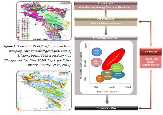
Prospective cartography (figure 1) aim to predict the probable locations of mineralization using cartographic datasets. Two main approaches exist:
• The “Knowledge-Driven” approach use metallogenical models, known metallotects and human expertise in order to pre-process the available data before calculating the prospective model. This approach work well on areas that have been studied in the past.
• The “Data-Driven” approach is based on machine learning and use spatial and statistical tools to establish correlations within the datasets, without any prior metallogenical hypothesis.

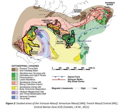
This “Data-Driven” approach will be applied during this thesis on many locations along the variscan belt (figure 2). A validation test will be first performed on the Armorican Massif and the Northern Massif Central, before the application test(s) on the Central Iberian Zone and, if so, on the Moroccan Variscan Massif. A higher scale study will be then conducted throughout the Ibero-Armorican Arc to see the correlations between our results at a different scale.

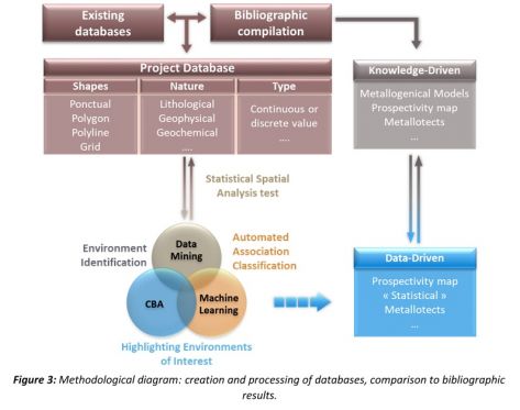
This “Data-Driven” approach will combine data mining, artificial intelligence and prospectivity methods (figure 3):
- The Data mining method will perform statistical spatial analyses on the database, allowing the pre-processing of the data and the creation of new variables and datasets.
- The Artificial intelligence method, and more specifically machine learning, will use the pre-processed data to identify the associations between the cartographic datasets and the mineralization to create a classification of this associations.
- The “Cell Based Association” (CBA) is a prospectivity method that allow the discretization of cartographic environments. The continuous datasets are transformed into a grid cells where each cell correspond to a cartographic environment, a combination of cartographic features. With the classification established through machine learning, it is then possible to highlight environments of interest, “favorable area” where mineralization are most likely to occur.
The database used to perform all this method will be created by compiling as much data as possible from existing databases and bibliographic sources. This will include lithological, structural, geochemical and geophysical datasets.
The results of the “Data-Driven” method applied during this study are to be compared with “Knowledge-Driven” bibliography, to validate the prospectivity maps and “statistical metallotects” obtained. If valid, the results of this method would improve our knowledge of mineralization in the studied area, lead to a better understanding of the metallogenical models while giving a new prospectivity-mapping tool.
1Gloaguen, E., & Tourlière, B., 2016. Revalorisation du potentiel minier français. Méthodes prédictives appliquées à la province à antimoine du Massif Armoricain. (No. RP-65534-FR). BRGM.
2Barth, A., Knobloch, A., Noack, S., Hielscher, P., Etzold, S., & Brosig, A., 2017. Mineral predictive mapping - from intuition to quantitative hybrid 3D modelling. Mineral Prospectivity, current approaches and future innovations. Orléans, France, 24-26 October 2017.
3Catalán, J.R.M., 2011. The Central Iberian arc: implications for the Iberian Massif. Geogaceta n°50, p. 7–10
Alex Vella personal presentation
Alex Vella, French PhD student working with the ISTO and the BRGM at Orléans, part of the AUREOLE project.
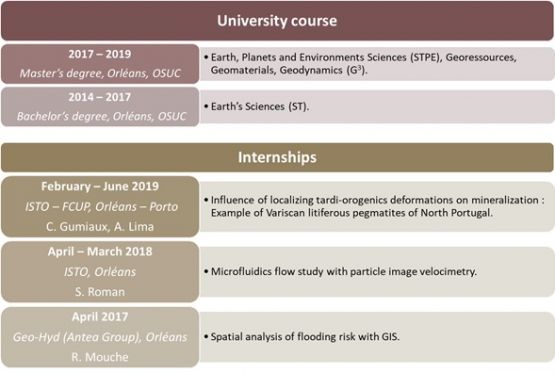
Graduated from the Observatory of the Sciences of the Universe in the University of Orléans (OSUC), I hold a Master’s degree in Earth, Planetary, and Environmental Sciences - Georessources, Geomaterials and Geodynamics course (STPE – G3). My main interest in geology is the study of geological processes with informatics tools and numerical models. Beside geology, I like science fiction, tabletop games and history.
During my University course, I had the opportunity to work on various subject trough projects and internships, mainly in the thematic of data analysis and treatment (spatial analysis, geostatistics, image analysis …) applied to geosciences. Those experiences concern especially the use of geomatics for spatial analysis.
In 2019, as a validation for my Master’s degree, I have worked with the FCUP (Porto) and the ISTO (Orléans) on the influence of localizing tardi-orogenics deformation on mineralization of variscan litiferous pegmatites of North Portugal. This work aimed to study the links between pegmatites, mineralization and tardi-orogenics structures by using spatial statistical analysis, ground observations and lineaments study.
Before this, I had the opportunity to work on geomatics applied to risk analysis as an intern in Geo-Hyd (Orléans), part of the Antea Group, in 2017. I worked on the flooding risk in some area of France, identifying stakes, calculating possible damage costs and establishing regulatory risk maps.
Beside geomatics, I also had the opportunity, through an internship in the ISTO in 2018, to work on computer vision and image analysis applied to CO2 storage. I studied fluid circulation inside microfluidic models with different geometry, using micro particles. The photos obtained by a high-speed camera were processed to calculate the fluid velocity field and observe its behavior.


